- About
- Departments
- Construction on Campus
- Service Requests
Back to Top Nav
Back to Top Nav
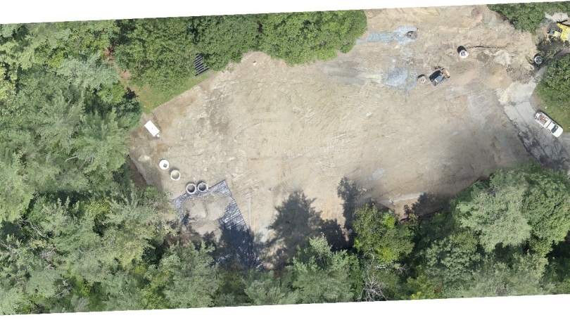
The office of Planning, Design & Construction (PDC) has recently invested in a Campus Services drone program to be more efficient in collecting and sharing data. The program improves monitoring and reporting on construction projects, and provides unique building assessment opportunities with exceptional resolution at a fraction of the cost of traditional methods. Partnering with the Thayer School of Engineering, PDC's drone program currently uses a high-end consumer grade DJI Phantom 4 Pro drone with exceptional video and image quality.
Kevin Nelson (Spacial Database Manager) and Geoff Whitchurch (Space Data Technician) are PDC's FAA-licensed drone pilots, permitted to fly drone missions over Dartmouth's campus following strict FAA and Dartmouth guidelines.
Two recent projects have proven useful to PD&C operations including the monitoring of the construction of the Channing Cox parking lot on the west end of campus, and the development of a Moosilauke Ravine Lodge area map. The use of drones enables PDC to automate pre-planned flight missions which replicate exact flight paths allowing planners to revisit and monitor projects. Using photogrammetry software, PDC can stitch together multiple drone images covering larger areas. Below is a single image of the Channing Cox parking lot stitched together from 52 drone images that were taken from approximately 150 feet above the ground.
Future projects using drone imagery and video will include: monitoring the Thayer Expansion project and monitoring the construction of the Irving Institute. The drone perspective creates a unique and informative view of the earth and can deliver up-to-date aerial imagery for immediate planning projects. Drone capabilities also provide a safe alternative to infrastructure monitoring, including performing: rooftop, chimney, building, bridge, and tree assessments.